California Department of Transportation (CalTrans), through its traffic operations and New Technology and Research Program, in coordination with program partners, has enabled the development and implementation of a state-of-the-art Transportation Management Center (TMC) in District 12 (Orange County) headquarters. In addition to meeting stringent functional requirements, the TMC’s unique attributes include provisions for an Advanced Transportation Management System (ATMS) Testbed with high capacity communication links to the university laboratories intended for real-world testing and evaluation of near-term technologies.
The TMC-Testbed system is based on real-time computer assisted management, communication and control strategies with capability to expand its application to all transportation modes, including transit systems and commercial vehicles. The overall goals of the system are to improve the safety, productivity and energy efficiency; reduce traffic congestion; improve intermodal connections and reduce air pollution.
National Engineering Technology Corporation (NET), a multinational engineering consulting organization offering services in Intermodal Transportation Manage ment Systems (ITMS), including communications design, software development, computer design and system integration, is a key player in the delivery of the ATMS. NET developed a new computing environment consisting of UNIX-based workstations and servers, front end
communications processors, a TCP/IP ethernet based network, a Closed Circuit Television (CCTV) network and SL-GMS software as a dynamic, interactive graphical user interface.
The heart of the ATMS is a distributed processing network of UNIX work stations utilizing the TCP/IP protocol. Through the TMC communications network, the se1ver receives field data from front encl communications processors. The information is then available to the ATMS software, which analyzes and reports traffic conditions and also stores the data in a relational database.
The field data is gathered from microprocessor controllers strategically placed along the transportation network.
The microprocessors gather traffic information from sensors and control the meter signals of the freeway on ramps. Information from the microprocessors is relayed back to the TMC through communications networks.
The data includes information on various traffic parameters, including volume, speed and occupancy.
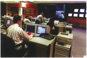
The users of the system, the TMC operators, interact with the system through the SL-GMS software. Each workstation utilizes dual 1024 x 1280 high resolution monitors. The operator opens several windows on both of the dual monitors and each window displays a map image of a section of the freeway network. The maps change color, blink and react in real-time to convey system traffic conditions. Commands are issued to
the system via point-and-dick interaction with SL-GMS objects.
TMC operators monitor the system’s network for nonrecurring and recurring congestion. Nonreccurring congestion is caused by accidents and other stoppages. Recurring congestion is typically due to normal morning and evening rush hour traffic. The ATMS software uses internal algorithms that analyze traffic information and look for changes in the traffic flow to determine if an incident has occurred.
The operators’ displays are the result of a large exercise in integration, simplified via the SL-GMS software’s powerful drawing tool, SL-DRAW2.
The SL-GMS objects were integrated with existing traffic management applications that include windows created with the UIM/X Motif tool, as well as Thomas Brothers maps. The maps were imported into SL-GMS as the base, with the dynamic objects placed on top. The integrated display is seamless to the operator, who can also issue commands through the SL-GMS-created objects.
For example, the operator has the choice of opening several windows on both monitors, each window exhibiting the network’s traffic information in real-time. The operator typically opens at least one window with volume information and another with speed information. Both will display dynamically.
The freeway map displays the traffic data and that information changes in color on the map as the volume changes. When the application software determines that an incident exists, a flashing object will be created at that location on the screen map. The operator clicks on the flashing icon and the ATMS brings up windows to guide him through a dialogue in which he is asked to confirm that the incident exists. As part of one of the confirmation procedures, the system automatically brings up different images from the CCTV. This allows the operator to visually verify the identified incident at the freeway location.
The operator station is integrated with an expert system, initially developed as part of the Testbed program at the University of California in Irvine, which responds to operator input with an action response plan for the operator to perform. The operator may be instructed
to contact the California Highway Patrol and to contact CalTrans Incident Management Response Team or CalTrans maintenance personnel. The ATMS expert system also recommends messages for Changeable Message Signs (CMS) located at critical points along the freeway network. When the messages are displayed on the freeway, the SL-GMS software makes display icons on the operator’s screen which are miniature replicas of the current message on the sign, along with the sign’s map location.
NET is also enhancing the ATMS to provide congestion mitigation through freeway network expert system analysis and ramp metering control. When complete, the enhancement will utilize the SL-GMS software as its interface.
Operators may also use the drag-and-drop capability of SL-GMS objects to manually declare an incident. If the operator believes that congestion warrants the declaration, the appropriate icon is selected and dropped on the map. The expert systems will then begin functioning.
Finally, the TMC personnel can operate the CCTV cameras through the SL-GMS interface. The camera sites are displayed as an icon on the map. The operator clicks on the icon and the system opens a window with the picture from the camera and a graphical camera control panel. The operator clicks on objects on the control panel window to issue camera control commands (pan right, pan left, tilt the camera, etc.) to control the viewing area. All responses and actions occur in real-time.
A number of features convinced NET to select SL-GMS software for the user interface. First, it provides the ability to present dynamic information and display that information in reference to a geographic map display. In addition, operators are able to navigate around the system on a geographical basis. Only SL-GMS could meet the application’s pe.ilormance requirements, providing real-time display and control for this large map based application.
Switch to a smarter, more flexible and easy-to-use graphical modeling software.
Try SL-GMS